
-
DUMONT DUNES VISITOR GUIDE
Directions to Dumont Dunes
Driving directions from Baker, Las Vegas, and Pahrump, plus information about the access road, river crossing, and arriving at Dumont.
Dumont Dunes Off-Highway Vehicle Area is located in the Mojave Desert of California, approximately 34 miles north of Baker along Highway 127. Whether you're towing a toy hauler, driving a motorhome, or heading out for a day trip, here's how to get there.
From Baker, California
Baker to Dumont Dunes
Approximately 34 miles north on Highway 127, plus the gravel access road.
- From Baker, take Highway 127 north approximately 34 miles.
- You'll pass Little Dumont Dunes on your right.
- Just past Little Dumont, watch for the Dumont Dunes entrance sign.
- Turn right onto Dumont Dunes Road, the gravel access road.
- Continue approximately 3–4 miles, crossing the Amargosa River wash on the concrete crossing.
- Continue past the entrance fee station and follow the gravel road uphill to the main camping plateau.
From Las Vegas — Tecopa Route
Las Vegas via Highway 160 & Tecopa
A common route from the Las Vegas Valley to Dumont Dunes.
- From Las Vegas, take Highway 160 west toward Pahrump, crossing Mountain Springs Pass near Mt. Potosi.
- Turn left onto Tecopa Road / Old Spanish Trail Highway.
- Continue toward Tecopa for approximately 30 miles.
- Turn left onto Highway 127 and head south for approximately 14 miles.
- Turn left onto Dumont Dunes Road.
- Follow the gravel road approximately 3–4 miles, crossing the Amargosa River wash.
- Continue past the entrance fee station and uphill to the main camping area.
From North Las Vegas — Via Pahrump & Shoshone
Indian Springs / Pahrump Route
An alternative route through Pahrump and Shoshone.
- Take US Highway 95 north toward Indian Springs.
- Turn left onto Highway 160 toward Pahrump.
- In Pahrump, turn right onto Highway 372.
- Continue west into California, where Highway 372 becomes Highway 178.
- Follow Highway 178 into Shoshone.
- Turn left onto Highway 127 south.
- Continue approximately 22 miles and turn left onto Dumont Dunes Road.
- Follow the gravel access road past the river crossing and entrance fee station to the camping plateau.
Dumont Dunes Access Road
Important: Dumont Dunes Road is a gravel access road approximately 3–4 miles long. It includes a concrete crossing through the Amargosa River wash and climbs to the main camping plateau.
Conditions can change following rain, flooding, or heavy traffic. Never attempt to cross flowing water, and check current conditions before traveling.
Do I Need 4WD?Normally, no. Most trucks, RVs, and trailers can reach the main camping area when road conditions are good. Avoid soft sand off the established road.
Watch Your SpeedThe gravel road can be rough and washboarded. Drive slowly, especially when towing a trailer or driving a motorhome.
River CrossingThe Amargosa River crossing can become impassable during or after storms. Do not enter the crossing if water is flowing or conditions are unsafe.
Download Your MapsCell service can be unreliable around Dumont. Save offline maps and directions before leaving town.
Dumont Dunes Area Map
This map shows Dumont Dunes and the surrounding towns and highways. Click the map to view the full-size image.
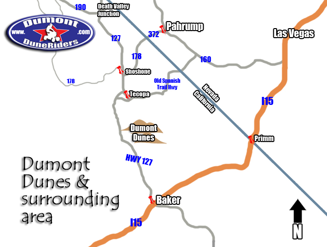
Click or tap the map to enlarge.
Before You Head Out
Plan ahead: Dumont is a remote desert recreation area. Bring plenty of water, fuel, food, and supplies. Check the weather, entrance pass requirements, and current road conditions before your trip.
-