

eli
-
Posts
197 -
Joined
-
Last visited
Content Type
Dumont News
Dumont Conditions
Dune Food
Forums
Calendar
Gallery
Posts posted by eli
-
-
snip
During a routine traffic stop...If you have a weapon in the car and you don't want them to search your vehicle simply get out of the vehicle with your paperwork in hand before they get up to you...only caution is getting out of the vehicle is going to put the cop on edge so make sure you are calm and keep your hands visible and wait for the cop to approach you, do not approach their vehicle. They have no reason to enter the vehicle to make the weapon safe if the weapon is not accessible to you. If you stay in the vehicle and declare you have a weapon they can only go into the immediate area in which you state the weapon is located, if it's in the center console they can only go into the center console.
Great theory....reality is somewhat different: I NEVER get out of the car unless requested to do so. I stick my hands out the window where the officer can see them. So if I'm handcuffed, standing in front of cruiser without any access to the center console and they tear the entire vehicle apart you would think that unreasonable....Not in Henderson in their eyes you declared a weapon and that's enough for them.
Oh and just fyi when a cop just runs your license plate the only info that comes back is DMV info, not your arrest history, warrants (unless a plate is linked to a warrant, info, stolen etc), firearms registration, etc. Those take more effort on their part and they don't always run those checks on routine traffic stops, they will usually only check dmv reg and warrants...of course all cops are different and all departments are different, but generally speaking. They use to not be able to check for gun registration on the computer, but I know they have changed the firearms registry and database since I worked there and I don't know what they can do now. I was stopped in Henderson just before the new year and he did extra checks on me that they normally don't do and still didn't mention my firearm registration, he did find that I had a 'P' number which is how I knew he ran the extra checks.
Used to be true but it appears the databases have been updated. I've been stopped when the officer didn't have time or any reason run anything but my plate. He asked if there was a weapon in the vehicle and I told him no because there wasn't. He said "the reason I asked is that it showed you had a permit which comes up now." I think Metro added it to their database. Metro has never supported "must issue" anyway although that's their boss's lobbying in Carson City and not all of the street cops views.
Eli
-
snip
Iam a law abiding citizen, and usually i dont care if a police officer wants to search my vehicle, then go right ahead, but if they are a jerk, then i just tell them NO. usually they ask if i have something to hide and i tell them no, i just dont think you need to invade my privacy in hopes to find something to write me a ticket. so....get a warrant...usually ill be on my way within 10 minutes.
Anyone who has been pulled over while driving can relate to the sinking feeling that strikes once the multicolor police lights ricochet off the rear-view mirrors and into the drivers sight. Once the cars are parked on the side of the road, the officer confidently strides toward the car and requests paperwork. Then, nonchalantly, he springs the question: Can I search your car?
Probable Cause
I don't think you EVER HAVE to consent. If they think they have probable cause they are gonna do it anyway. If they ask you if you have something to hide you still have the right not to incriminate yourself even if you are breaking the law.
The legal advise I got was: "There is case law supporting probable cause in every possible direction. It's simply a matter of finding a case that supports your situation." Unfortunately the DA knows that too.
CCW instructors in Nevada often tell you to declare the weapon during a traffic stop. That's simply common sense, nobody wants to surprise a cop with a weapon but to my knowledge there is no Nevada law requiring you to do so. In an interesting twist often applied in North Vegas and Henderson. When you tell the officer your CCW he may search your vehicle even without possible cause "because he's required to make the weapon safe" or so they will claim. So if he's run your plate through the database and it comes back you are a permit holder, can he then search your vehicle? I say not, he still doesn't have probable cause but North Vegas and Henderson disagree by their actions.
Regardless it's stupid position for them to take. IMHO it makes the streets more dangerous for everybody including the cop on the street. If you have the right not to incriminate yourself if you are doing so illegally, why would the street cops want to hassle somebody that's already gone through the permit process and clearly wants to be legal? The answer simply seems to because they think they can. Those that are legal should be able to declare without getting hassled over it especially when they are not required to do so.
IMHO These two cities and the officers that pull this crap truly belong in the state of California and it seems they would be in similar company at Tecopa.
Eli
-
Consider the aluminum skid plate from Dragonfire.
Rocks can dent your plastic stock skid plate deep enough and take out the Diff, crankcase and tranny.
We do have rogue rocks that pop up at Dumont.
Not trying to be an alarmist.
Just trying to save everyone some grief.
Remember to change your air box to something that actually works I like the Dragonfire (BTI) It's $$$ but installs without cutting and can be returned to stock without a hassle. Clean it every night without fail!
Don't put off the skid plate. My stock one came off in pieces. I'm not a big fan of aluminum skid plates. They protect OK and may be fine for the dunes but dent on the trail and don't slide over the rocks as well. It's 1/2" UHMV for me. Holtz center UHMV plate with aluminum sides and diff covers might be OK but from the look of my Polaris rock sliders the aluminum side protectors aren't gonna be pretty for long.
Eli
-
is there a way to get from Dumont to the China Date Ranch? I have been to the date ranch years ago (GREAT DATE Shakes) just curious
Thanks

Hasn't been legal up Sperry wash since 1974 but a lot of people did it. More difficult since BLM cabled the wash at Sperry in about 2002. About 5 miles from Western Talc Rd to the China Ranch turnoff via Furnace Creek Rd. Not that is legal either.
Eli
-
Several years ago I went up Sperry Wash to the mine and beyond up some good roads but I think I remember the rangers telling me that those roads are now closed to all but registered street legal vehicles. Am I mistaken???
Legally I think most roads in CA gravel or otherwise are closed to everything but street legal vehicles. Western Talc Rd. is an exception. A lot of ATV traffic on Furnace Creek Road at the end of Western Talc Rd. It's gravel at that point and less than a mile to Upper Noonday camp where you turn east to the Tecopa mines. A lot of ATV traffic up there too. The mines themselves are private property so Mr. Ranger can't say :poop: but be respectful.
Get the glasses out at the Columbia Mine and look north and you will see a different trail around the hill back to Furnace Creek Rd. You should be able to find the Tecopa RR at the Columbia but I haven't found it yet. A couple miles to the other branch of the Tecopa RR and follow that to the Gunsight. You still aren't to the China Ranch turnoff. Furnace Creek Rd. likely isn't legal itself so just get off it ASAP. I'd hope Inyo county views things differently than San Bernardino. Can't legally get to Riggs from Dumont anymore either.
I'm not sure how people are getting to China Ranch these days except on Furnace Creek Rd. I don't take a ATV in there out of respect for the owners but it may be mis-guided as $$$ may be $$$. Some day I'll ask them.
Not to give away one of my favorite spots but I've never seen a LEO. I can go to Dumont or I can go to the mines or I can go to the hot springs. Did lose a couple of tires on Furnace Creek Rd. New Years but that can happen anywhere. Other campers were very respectful even asked it we minded if they shot off fireworks which of course we didn't. Still didn't see a LEO they must all be at Dumont

Eli
-
Going out this coming Wednesday for a couple of days and want to take some Rhino trips to sites around Dumont. Alrady have done Sperry Wash, the T and T RR south past Riggs road and east of there to some mines and shacks.
Any other places that you know about that is good to see and accessable by Rhino??? Needs to be in areas that are not out of bounds areas!
There are some good things on the other side of 127 that I have heard of but would not like to have to trailer the Rhino just to cross the hiway!
Thanks,
Sperry Wash past Western Talc, to the Tecopa mines. The Gunsight mine via the Tecopa RR, difficult to find the RR if you don't know it's there and not exactly a high speed run but interesting none the less.
Eli
-
Is that grade the "CR 20554" that intersects it on Google Maps?
You're right, a 4x4 would be called for - but I'd like to pay somebody that is familiar with the area to take us there. We'll gladly pay for his/her time and gas.
The main mystery is, what route did they take after leaving Owl Hole Springs, and where did they go off the road? All we know (remember, this was back in 1923) is that it was a stretch where there were railroad ties laid lengthwise down the road. They slipped off of them and were stuck in the sand. This was in July, by the way.
They stayed with the car for 3 days, and when his wife and babies (3 months and 18 months) became unconcious, he dragged them to a "nearby shack" and left for help.
The only other thing we know is that it was nighttime when he staggered into the Riggs Section House and passed out on the floor. I don't know if he walked only at night, or what. In any case, I don't think he went off the road near Owl Hole Springs - that would have been WAY too far from the section house. Nobody in his condition could have walked that far.
I'm guessing he was walking on or near 127 (which hadn't been paved at that time), saw a light at the section house in the distance, and headed for it.
Thanks a bunch,
Ruark
Well when I didn't hear from Ruark I went ahead and posted the story on the T&T mailing list.
The wonderful news is the guy I was referring to is still able to return emails. He's not that much younger than Ruark's mother. His history is interesting. His father was killed in a flash flood in the desert. Strange way to die in the desert. He was raised for much of his life in a converted box car on a work train parked where ever needed along the T&T. He worked in many of the mines around the area. He went to college and discovered a better way of making magnesium and became very successful.
Well it was worth a try.....
He recalls that they were parked at Riggs several times and Valjean once. He doesn't recall that Saratoga Springs road had that much sand and doesn't recall a road with ties but says it's possible. He agrees Owl Springs seem too far for a man in that condition. I asked why Riggs and not Valjean which would have been closer and easier to see a light from 127. He replied that the road to Riggs was and is a freeway compared to the road to Valjean.
Gary
-
Is that grade the "CR 20554" that intersects it on Google Maps?
You're right, a 4x4 would be called for - but I'd like to pay somebody that is familiar with the area to take us there. We'll gladly pay for his/her time and gas.
The main mystery is, what route did they take after leaving Owl Hole Springs, and where did they go off the road? All we know (remember, this was back in 1923) is that it was a stretch where there were railroad ties laid lengthwise down the road. They slipped off of them and were stuck in the sand. This was in July, by the way.
They stayed with the car for 3 days, and when his wife and babies (3 months and 18 months) became unconcious, he dragged them to a "nearby shack" and left for help.
The only other thing we know is that it was nighttime when he staggered into the Riggs Section House and passed out on the floor. I don't know if he walked only at night, or what. In any case, I don't think he went off the road near Owl Hole Springs - that would have been WAY too far from the section house. Nobody in his condition could have walked that far.
I'm guessing he was walking on or near 127 (which hadn't been paved at that time), saw a light at the section house in the distance, and headed for it.
Thanks a bunch,
Ruark
I haven't had time to look for owl springs but the name rings a bell. The railroad was still in use in 1923 so the grade isn't the road you are looking for. Unless it was one of the Silver Lake realignments. Walking on 127 is unlikely though not impossible. I'm not sure exactly when they built it over the pass but the first road was a truck road through Sperry Wash from Western Talc Mine. Yep the same we travel today as an approved atv route.
Again join and post the story on the nvshortline list at yahoogroups.com. If anybody remembers anything or the tale was told....one of the members (who was raised in a boxcar along the T&T) may know something about it.
Eli
-
I wonder if it's the two buildings (one is the Riggs house) just to the left of Riggs Road's intersection with CR 20554:
CR20554 looks like it could be along a railroad bed or something. I don't see anything else out there.
Thanks,
Ruark
That white spot west of the road and by the co2 lettering appears to be it but you can't zoom it far enough to be absolutely sure.
Eli
-
I'm new here, posting from Texas. I'm not a dune rider (but it looks like fun!), but I seriously need some help in locating something in the Dumont area from you guys. Let me explain:
In 1923, my mother's uncle, "Uncle Bonnie" left Langsford with his wife, daughter and her two small babies. Heading east, they passed Leach's Point and Owl Hole Springs. This was in the hottest part of the summer, with no food or water. They didn't anticipate any problems (rolls eyes).
At some point after passing Owl Hole Springs, they encountered a stretch of road that was surfaced with railroad ties, as some were back then to help people cross a sandy spot.
Their car, probably a Model T (1923, remember), slipped off the edge of the ties and got hopelessly stuck in the sand. Uncle Bonnie got out of the car and it was so hot, he passed out and fell to the ground in a couple of seconds, and couldn't get back up. Finally he prayed for help, and the Lord must have heard him, because he then got up and started walking for help. The others walked over to an abandoned shack to get out of the sun and wait.
It was after dark when Uncle Bonnie staggered through the front door of the Riggs Section House and collapsed on the floor, almost dead. "Death Valley Jack" Nickerson (who is buried in Silver Lake cemetery) was there. Nickerson held his ear down to Bonnie's lips. A few seconds later, he was speeding into the desert. All were saved, but they barely made it. Those two babies are in their 80's today.
This March, my mother and I (she's 86, but tough as shoe leather) will be in Las Vegas visiting my father, and we want to make a side trip to that area. We want to try to reconstruct the route Bonnie took after leaving Owl Hole Springs, and if possible, find the place where he went off the road. I'm sure he went down what is now known as Saratoga Springs Road, but it's hard to tell. 1923 was a long time ago. Highway 127 was there, but hadn't been paved yet.
But one thing WAS there: "Riggs Section House." I did a Google search for it, and ONE single link came up: a post on this forum, back in 2007, from a guy named "Duneshredder." I understand it had a lot of concrete in the walls and much of it is still standing. Obviously, it would be fantastic to find it. Can somebody here please help me locate exactly where it is, preferably on a map? Is it visible in Google Satellite View?
I'm also checking around for somebody who could take us to Owl Springs. The roads to there are supposed to be well maintained, but we'll be in rented passenger car and it's never a good idea to take chances in the desert.
I sincerely apologize for coming in here, not being a dune rider, but you guys are my ONLY hope to find that place.
Thanks very much,
Ron Morgan
Ron,
I'm a Tonopah and Tidewater Railroad fan out of Las Vegas and have been to Riggs many times. If I'm working in March somebody from the Tonopah & Tidewater mailing list at yahoogroups.com might be able to lead you out there. Simply search for the Tonopah and Tidewater group and send a email to the list owner. That's me. Consider renting a 4 wheel drive mostly for the sake of your mother. Legally you will need to come in from the south. Riggs Road is north of the cemetery at Silver Lake. The Section House is very close to intersection of Riggs Road and the Tonopah and Tidewater Railroad grade.
Unlike most other section houses on the T&T the end walls at Riggs were made of concrete. They remain although fallen. Like many stops on the T&T Riggs was dry and water was hauled in, the cistern remains.
PM me on this list with your email and I will be happy to help in any way I can, I am rather busy for awhile but will get maps sat photos and GPS info off to you when I get time.
There's also a Tonopah and Tidewater website that may be of help to. Simply google Tonopah and Tidewater.
Eli
Now that I think about there a couple of mailing list members from Texas. I should be able to put you in touch with them as well.
-
easy, go up wash to date farm, take road over mountain where mine is, drop down into sandy valley(old cima -tecopa road), over mts from sandy valley and drop into primm from west side. there shouldnt be any closed areas and this old road is basically abandoned so shouldnt be problem with atvs. done it many times on motorcycles and never see a sole anyway.
I thought about the old Tecopa RR grade which gets you to either the Gunsight or the Noonday mines but don't know how to get over the mountains without the paved road over Tecopa Pass.
Which wash would that be? Sperry? There's been cable, posts, and signs at Sperry turning you east on Western Talc for several years. Been an ACEC at the barbed wire fence about 3 miles north of Sperry since about 1974. Was so overgrown with Salt Cedar at the T&T bridge location you couldn't even hike it about 7 years ago. Which still leaves you several miles south of the date farm via Sperry Wash. Turning south at Old Tecopa then east runs you pretty much around the mountains. Kind of looked like Kingston and a County Rd would get into you to Primm but that's on a map. I don't know on the ground never tried it.
Eli
-
Just curious has anyone rode from dumont to Primm? I think it would be a fun day trip. Need your feed back.
That's gonna be legally a little hard.....if not impossible. Which of course makes it interesting:)
The wilderness starts 50' east of the T&T grade which runs the entire east side of dumont. Another starts south on that grade before you reach Valjean. So the grade is out to south as well as east out of Dumont. West maybe a problem and it doesn't matter because you aren't gonna be able to do much even if you reach Baker. The preserve on the other side of 15 is off limits.
North up Sperry Wash then East on Western Talc Rd. will get you to Old Tecopa as opposed to present day Tecopa. If you turned south from there I think there may be a gravel road that will get you out of CA and into Nevada. From there I'm really not sure but encounters with the LEO's might be less severe in Nevada.
Eli
-
well I am glad there is no rail road at dumont, but those environmental freaks do worry me
Well the ties are for the most part gone. The rail is gone but the railroad grade is still there. Those big
 cuts and fills NE of the dunes weren't put there so you can trail ride. After you enter the pay station if you go to the left instead of up the hill, in other words up the gully....the big wall of dirt at the end is really a filled railroad bridge. On top of that fill on the dunes end the bridge timbers were coming through the dirt last time I was there.
So why should you give a :poop:? The wilderness area is defined as 50' east of the centerline of that grade which runs east of the dunes for the entire length of the area. A fact that seems to escape the notice of the BLM that put up the damn signs. One of the best examples of which was at the other end of the bridge and was located well WEST of the grade.
Eli
-
thanks p rhino it is...
If you got the bucks for custom cage that's the place to go. If you don't have the bucks if he doesn't have a take off cage I'll bet he will have before long for....cheap.
Eli
-
and a sadistic bastard!..
since Ken lives right across the street from me. I see him all the time..well i get a phone call today telling me to come over to his house...he has something to show me....
he has sucessfully anailated a horde of bees!
this is the horrifying site that i saw!
Caution...may not be for the weak to see!!
:dumbass:
as the mad man approaches!

:poop: Anybody that wears that shirt has got to be from Nebraska...and I thought I liked him because he helped me out with Logandale info couple years ago.
BTW Ken KILL EM ALL...bee stings make me sicker than :poop:
Eli
-
I know Im just :stir: but what is the big deal about shooting a gun and who are you thinking of when you pull the trigger?? I have only been shooting once in my life . and i didnt get big of a thrill from it. But then again most men dont get thrills out of pedicures either lol
I'm not thinking of anything but hitting what I'm shooting at. That's one reason I do it, it's a great way to get your mind off other things. Should your life depend on it...you better not be thinking but reacting. That's where lot's of practice comes in. There is plenty of time enough for thinking before and after the shooting is done.
Eli
-
Maybe someone needs to buy this book..
Written by Harry P. Gower who was a long time Death Valley pioneer and this book is full of anecdotes and stories of what he experienced between the years of 1909 to 1960.
If nothing else I am getting a great history lesson on Death Valley with all this Googling ans researching!
Good topic

Gower is a good read. The Tincal Trail is dry as a popcorn fart in places and likely to be of interest only to those as strange as me. Which is maybe why I forgot about Dumont. So why did I reach for it in addition to Gower?
Borax Smith and 20 Mule Team Borax are as American as apple pie or are they? The Tincal Trail is as English as High Tea. Why are a couple of limeys writing about Borax?
Smith consolidated his borax holdings into Pacific Coast Borax Company in 1890. He merged PCB with Redwood and Sons in about 1896. The company name became something so long I'd have to look it up. In 1899 this company became Borax Consolidated Limited. Smith was the majority stockholder and one of two directors with RC Baker being the other. That's how Baker CA got it's name.
So where are most of the company records for Borax Consolidated Limited? Across the pond.....it's an English Company. Pacific Coast Borax continued to exist as a company without any assets for a long time. Likely because Smith didn't want it known that American 20 Mule Team Borax wasn't owned by an American company anymore. So where's that leave the Tonopah & Tidewater Railroad and my beloved....not BLM? I'll get to that in another post.
Eli
-
Could Eleanor Dumont have been one of his associates ????? Lady Moustache ? Read my prior post, she is the only person I can think off that had influence in the area.
Or not she died in 1879......
"According to one account, Mrs. Dumont woke one morning in 1925 to find a note on the bureau. It read Bye-Bye, Baby Bunting, Daddy's gone a-hunting." Apparently the English authors (below) found some humor in that. At the time Harry Dumont was the General Sales Manager of Pacific Coast Borax.
But was he really the one Dumont Dunes is named after? Smith's habit seems to have continued but was there another Dumont? Smith is long gone from Pacific Coast Borax before Harry Dumont even makes Sales Manager.
Apparently Smith pensioned off a "Mr. Dumont" for a dollar a day long before. This "Mr. Dumont seems to have entered the Company's service when he was over 70 years of age and appears to have continued in this service for 9 or 10 months.." This apparently written in 1914. So Daddy went a-hunting at over 81? There is a Harry Dumont in 1906 a officer of PCB in New York and again in Chicago in 1925 a Sales Manager. The same? Father and son?
I really wouldn't :poop: you over something this strange. The above is from the "The Tincal Trail A History of Borax" written by N.J. Travis and E.J. c*cks (Hey I wouldn't :poop: you about that either. It's really his name) Published in London in 1984.
Eli
-
If the bridge was where the tracks crossed to the east side (right) going toward Tecopa, yes, I was right there in the 1st pic. The cattle were at a wide area just after the fork (Tecopa/China Ranch) toward Tecopa.
Yep it was an interesting bridge at least to a railfan like me. I can't seem to find a picture of it on the web right now. The cattle would be closer to what at least the guy that ran them called the Bowel.
Eli
-
Are you referring to the military control airspace or is ACEC area of critical environmental concern? The airspace at that time had a 3000 ft ceiling.
Area of Critical Environmental Concern. I was told 3000' Above Ground Level. Permission was granted several years before from the NPS to low fly the DVP but it was denied later. Somebody wanted to something to do with dropping water on the highest and lowest points in the US.
In any case it was a no go with the BLM.
Eli
-
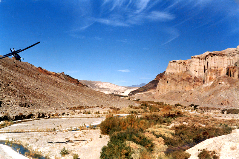
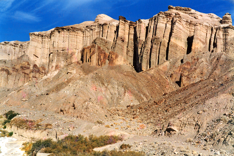
These are clearly what are called the Palisades. I tried to get somebody to low fly the area about 8 years ago when I was doing a low budget movie but it didn't happen because it's an ACEC and been one since 74. I for one am glad you where slightly off course.
Looks like the T&T grade in the foreground just past the bridge site.
Eli
It's clearly the bridge site. The doggies may be located just south of there or in what's called the Bowel just south of Tecopa I can't tell. Both were overgrown with salt cedar last time I was there and the BLM removed them doggies long ago.
Eli
-
Just scanned these from about 20 years ago.
I'm on the deck and my flying bud is in the blue plane, he flew to Dumont from Apple Valley
 The cliff on the right is the next pic looking straight at it.
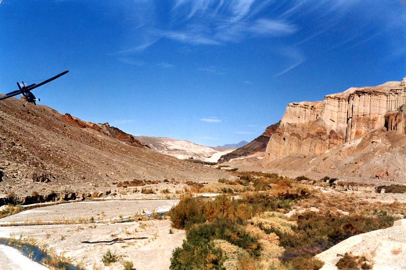
Hard to see in this small pic but the dark reddish spot in the middle looks like Bigfoot in the big pic

These are clearly what are called the Palisades. I tried to get somebody to low fly the area about 8 years ago when I was doing a low budget movie but it didn't happen because it's an ACEC and been one since 74. I for one am glad you where slightly off course.
Looks like the T&T grade in the foreground just past the bridge site.
Eli
-
you should not be so greedy...iam married to one who is less fortunate in that dept. Now that she is pregnate her boobs are finally bigger than mine.
Depends on how you look at it. The bigger they are the harder they fall....So I'd have to say I'm married to one that is MORE fortunate in that dept. Not that I haven't wondered....
From hero to back in the :poop: house again.....in a single post.
Eli
-
A group " Senior Moment"
I'm in for that!!!

I only have a couple of years duning but I have a couple of decades poking around the desert. Does that mean mean I :hungry: enough? Don't answer that.
Eli


Inyo PO POs in Tecopa Monday handing out tickets
in General Chat
Posted · Edited by eli
First Don't exit the vehicle, stick your hands out the window. Two kinds of people do that...felons and permit holders. The cop will figure out which you are fast enough. Felons don't normally declare weapons they aren't supposed to have:)
Second My point exactly Vegas hasn't started this........yet. Your buddies don't appear to be dumb as a pile of rocks. Some others....not so much.
Eli