Mid February Rain, Summit and Crusty Bunny Ranch
-
- By Landsandcrab
- 0 comments
- 3,905 views
It was a great trip with 8 guys and one gf. Drove out from Big Bear with light rain from Barstow, turning heavy after turning toward Baker. Heavy winds and more rain that fortunately lasted until midnight, then was quiet as a mouse! As you can guess, the conditions were amazing the rest of the trip! We did plenty of dune riding, a side trip to the infamous "Crusty Bunny Ranch" (southeast of Dumont), and a long 180 mile loop to Furnace Creek via Harry Wade road. Saw plenty of prudy wildflowers....we nailed it on the timing for this decades Super Bloom, by accident, sweet! Dantes View was also on the agenda. The rest of the crew did another side trip up Sperry Wash to gulp down a few Date Shakes at China Ranch date farm, so I got bored and decided what the hell I'm going to find out what is on top of that big mountain to the east of the Little Dunes!! Check out the pics for the killer views....
Planning another trip next week and probably one more mid month if the weather holds up. Enjoy!
WET and FUN

This sunsets for you Barrie Morris....RIP

Miss ya Mate

Anyone ever slept next to your ride when it's raining? I can cross that off the list! Clancy, Coors lite, CRF

The gang, mid 30's to the mid 70's and we ain't talking temperature!

Crusty Bunny Mine

Inside the earth

Terry checking out old headframe

Wet desert traction for days

Apparently, the Crusty Bunny Ranch has been closed for some time....

Near Ashford Mill in DV

Super Bloom!

About 150 miles into the 180 mile loop, east entrance to DV. Red Bikes galore!

Sperry Wash was running

FYI, the "Death Valley Internet Cafe" is in Tecopa, 20 minutes north of Dumont. They offer FREE WIFI, great food, beer and wine and a great atmosphere. Checkitout!

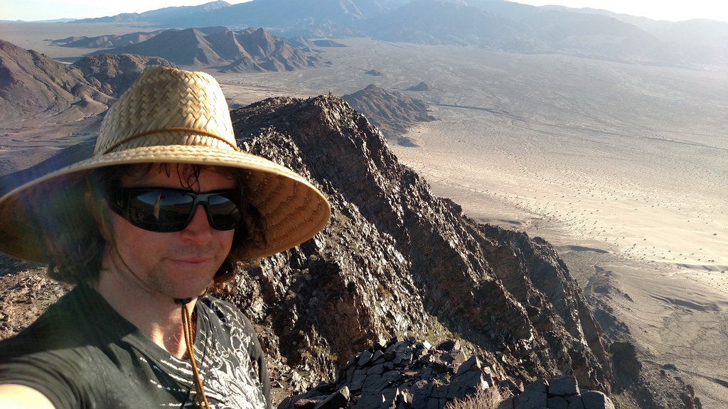
You seen this mountain behind the Little Dunes? I decided to see what was on top. Started (hiking) from camp, went up the "road" that goes to first little peak, found a goat trail that climbed to next peak, and then worked north/left to Summit. Very nasty scramble down but totally worth the effort!

Halfway up. Not much of a trail eh?

Made it to the top! There was a large rock stack, some possible sleeping circles, sentry post, and of course a killer view! Can you see our ring of campers (middle, just before Hwy 127)? Note water flow and cool dune formations!

Mandatory Summit Selfie!

Rock and Sand contrast

Love us some DD! See ya soon!
Recommended Comments
There are no comments to display.
Join the conversation
You can post now and register later. If you have an account, sign in now to post with your account.